When settlers came to this area, they found an abundance of trees, wildlife, and sources of water. The first inhabitants were probably prehistoric Indians knows as the Mound Builders. There are several sites located by rivers and river bottom lands in Southern Illinois. Although there were several tribes in Southern Illinois, the most predominant tribe was the Shawnee.
This area was the first part of the state to be settled and settlers who came from Virginia and North Carolina were English, then there were the French settlers who came south from Canada. A conflict arose between the ownership of the land from France and Great Britian. This conflict was settled after the 1763 Treaty of Paris which ended the French and Indian War and forced the French to cede the land to Britian. After the second Treaty of Paris was signed at the end of the Revolutionary War, the United States then owned all the land claims from Great Britian. In 1787, the Continental Congress passed the Northwest Ordinance which organized the territory west of the Allegheny Mountains and north of the Ohio River into the Northwest Territory.
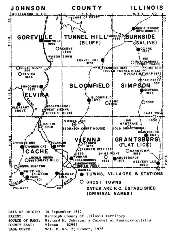
In 1790 three counties were established in Illinois: St. Clair County and Knox County in 1790, and Randolph County in 1795. These three counties were now a part of the Indiana Territory. The current area of Johnson County was then a part of Randolph County and Knox County. The Illinois Territory was established in 1809 and included Illinois, Wisconsin and part of Minnesota.
Johnson County was established in 1812 and included land from what now is Alexander, Jackson, Johnson, Massac, Pope, Union, and Willaimson counties. Between 1816 and 1843, parts of Johnson County were created into other counties, including Jackson and Union counties when Illinois became a state. It was not until 1843 that Massac and Pulaski counties were formed from Johnson County.
Johnson County was named in honor of Richard Mentor Johnson, from Kentucky, and a war hero in the War of 1812. He also served in the U.S. Senate, and in the U.S. House of Representatives, and was even elected Vice President in 1837. He served under President Martin van Buren.
The almost square county is made up of two distinctive types of geography. To the north and east the land is rugged with giant rock formations to low level swamps. To the south and west, the land is comprised of rolling hills and rocky creek bottoms that flood easily. The south and west areas have drainage from the number of creeks and rivers.
The area is known for the different habitats because of the different areas of land. There are plants and trees that grow well in the swampy areas of the land to woodlandplants and beautiful streams. Many varieties of trees are fouds in this area too. Because of the fertile lands and plants, animal life in the county is abundant. Birds are also plentiful, with reptiles and amphibians as well as snakes living there.
From 1812 to 1814 several dwellings west of Elvira were used as the county seat of Johnson County. In 1814 the seat of justice was moved to Elvira, a little to the west of Buncombe, Illinois. It was centrally located in the large county. The county courthouse was built out of logs and was 30-40 feet long. The bid to build it was $260. During May 1818, the county voted to move the county seat to Vienna. Another building was built as the county courthouse. In 1839 another order for another new courthouse was given, but today, no one is sure if it was actually built. The current courthouse was constructed about 1869-1871, with a total cost of $80,000, and was either the 4th or 5th courthouse built in Johnson County.
This courthouse has functioned continuously since its opening. Currently, a new courthouse/county building is being constructed one block to the west. The current courthouse was added to the National Register of Historic Places in 2010. Around 1908 the interior of the building was rearranged with fire proof vaults and heating plant added, and local water supply installed. During the 1960's the courthouse got a much needed facelift with sandblasting and tuckpointing. The east and west entrances were sealed up to create more offices. The landmark tower clock still strikes the hours. The cannon in the northwest corner was used during the Civil War, and was secured by P.T. Chapman during his term in Congress from ths district. The boulder and tablet in the northeast corner was placed by the DAR and contains the names of Revolutionary War soldiers buried in Johnson County. Next to it is a table commemorating George Rogers Clark's Trail through Johnson County. The millstones on the south side of the courthouse were found near Karnak, and were likely from a local grinding mill.